
Space Coast · Brevard County
Merritt Island Real Estate Investments
The Ligon Group evaluates Merritt Island real estate investments across an unincorporated Brevard County market where established residential neighborhoods, canals, riverfront homes, Sykes Creek, redevelopment corridors, wastewater infrastructure and direct Space Coast access create highly property-specific investment conditions.
Merritt Island is not a municipality with its own city zoning department. Residential property is generally evaluated through Brevard County Future Land Use, zoning, floodplain, utility and development regulations, with additional redevelopment, environmental and infrastructure layers depending on the parcel.
Island Geography · County Rules · Water
Merritt Island Is a Residential Market Defined as Much by Water and Infrastructure as by Neighborhood.
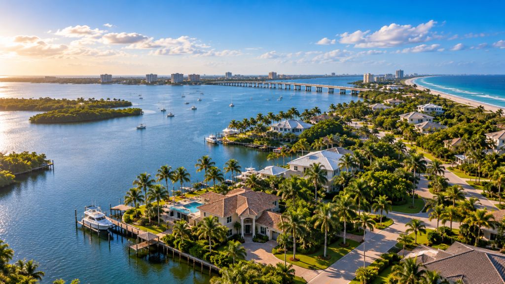
Merritt Island extends through a long north-south geography between the Indian River and Banana River systems, with Sykes Creek and numerous canals creating additional waterfront and drainage relationships through developed residential areas.
Housing ranges from conventional inland subdivisions to canal-front neighborhoods, direct riverfront homes, older established properties, larger South Tropical Trail parcels and more rural or environmentally constrained areas farther north.
Unlike the incorporated cities elsewhere in the Space Coast cluster, Merritt Island remains primarily under Brevard County land-use, zoning, utility and floodplain administration.
The Ligon Group therefore evaluates the actual parcel, water relationship, infrastructure and county regulatory framework before assigning an investment strategy.
Residential Market Structure
Four Merritt Island Environments Create Different Investment Priorities.
An inland subdivision home, Sykes Creek canal property, South Tropical Trail parcel and central redevelopment-area property should not be evaluated through one uniform model.
Existing Homes + Existing Infrastructure
Conventional residential neighborhoods shift the investment focus toward building condition, permit history, zoning, utilities, drainage and modernization.
Waterfront Value + Seawalls + Docks + Flood Exposure
Canal-oriented property can add seawall, dock, boat-access, shoreline, elevation and drainage conditions to normal residential underwriting.
Direct Waterfront Property Carries a Different Site Profile.
Riverfront homes can combine significant location value with shoreline infrastructure, flood exposure, wind, elevation, landscaping and environmental considerations.
Larger Parcels + Different Development Patterns
The island's northern and southern reaches include residential property that can differ substantially from the denser SR 520 and central-island development pattern.
Unincorporated Brevard · Future Land Use · Zoning
Merritt Island Property Analysis Starts With Brevard County—not a City Hall.
Merritt Island's unincorporated status is one of the most important distinctions in the Space Coast market hierarchy.
Brevard County Planning and Zoning administers the Future Land Use and zoning classifications governing unincorporated property.
Both classifications matter. Future Land Use establishes the broader development policy while zoning establishes more property-specific standards and permitted uses.
Additional county review can involve redevelopment-area consistency, floodplain regulation, utilities, wetlands, transportation or environmental conditions depending on the parcel.
Asset + Water + Infrastructure
Waterfront Location Does Not Replace Residential Underwriting.
Merritt Island can offer unusual water access and Space Coast proximity, but those advantages can carry substantial physical and infrastructure obligations.
Existing homes can require roof, HVAC, electrical, plumbing, windows, structural or interior modernization. Waterfront homes can add docks, lifts, seawalls, revetments or other shoreline improvements requiring separate condition analysis.
Septic or sewer configuration, drainage, elevation and canal relationships can materially affect the capital plan.
The Ligon Group combines acquisition basis, building condition, county zoning, utilities, wastewater, shoreline infrastructure, flood exposure and improvement scope before determining the investment strategy.
Merritt Island Redevelopment Agency
Merritt Island Has an Active Redevelopment System Even Though It Is Not an Incorporated City.
The Merritt Island Redevelopment Agency gives the central commercial and transportation spine a formal redevelopment framework within county government.
MIRA Operates Under Brevard County Authority.
The Board of County Commissioners established the Agency's governing structure under county ordinance and appoints its Board of Directors.
Redevelopment Focuses on the Island's Main Commercial Core.
Development inside the redevelopment area is coordinated against the Merritt Island Redevelopment Plan and its objective of improving the central business district.
MIRA Continues to Hold Board Meetings and Review Development.
County records show active Merritt Island Redevelopment Agency agendas throughout 2026, confirming that the Agency remains an operating redevelopment entity.
Corridor Reinvestment Can Affect Nearby Neighborhoods.
Housing close to SR 520, Courtenay Parkway and central-island commercial areas should be evaluated with traffic, redevelopment and land-use transitions around the property.
SR 520 · Courtenay · Barge Canal
The Merritt Island Redevelopment Area Expanded Beyond a Single SR 520 Intersection.
The current redevelopment geography was built through multiple additions over several decades.
Brevard County GIS records the original redevelopment area around the SR 520 commercial core, followed by later additions involving East Merritt Island, North Courtenay Parkway, the Barge Canal corridor and an area near Cone Road.
That creates a multi-part redevelopment environment following the island's principal transportation and commercial spine rather than one compact traditional downtown.
Residential property near these corridors should be evaluated for transitions in use, road access, traffic and redevelopment context without assuming every Merritt Island parcel lies inside MIRA.
Indian River · Banana River · Sykes Creek
Merritt Island Has Multiple Types of Waterfront Residential Property.
Waterfront exposure should be categorized by the actual water body and property infrastructure rather than treated as one generic amenity.
Western Riverfront + Wide-Water Exposure
Indian River property can combine open-water views with docks, shoreline improvements, tidal conditions and direct flood exposure.
Eastern Waterfront + Space Coast Geography
Banana River homes connect residential property with the eastern side of Merritt Island and the larger Kennedy, Cape Canaveral and beachside geography.
Established Canal Neighborhoods + Wastewater Infrastructure
Sykes Creek neighborhoods combine residential canals, boating infrastructure and active county sewer projects.
Seawalls + Docks + Boat Lifts Become Part of the Asset.
Canal homes should be evaluated for shoreline condition, dock and lift condition, navigability, drainage, elevation and the cost of maintaining waterfront improvements.
Sykes Creek · Sewer · Septic Conversion
Wastewater Infrastructure Is Changing in Existing Merritt Island Neighborhoods.
Brevard County operates the Sykes Creek Regional Wastewater Treatment Facility on North Merritt Island.
At the same time, the Save Our Indian River Lagoon program is extending centralized sewer into selected existing residential areas where septic-system nutrients can reach the Lagoon.
As of September 1, 2026, Sykes Creek Zones N, M and T are in active vacuum-sewer construction, with county updates describing construction periods extending approximately two years.
The Ligon Group therefore verifies current wastewater service, septic condition, planned sewer availability and potential connection obligations before establishing a property-level capital plan.
Indian River Lagoon · Septic Overlay
Merritt Island Is Inside Brevard's Most Sensitive Wastewater Geography.
County environmental mapping applies its Indian River Lagoon septic overlay across Merritt Island, making wastewater configuration a long-term residential due-diligence issue.
A Functioning System Today Can Still Carry Future Infrastructure Risk.
Existing private wastewater should be evaluated for age, condition, parcel configuration and current county environmental requirements.
Availability Can Change as County Projects Advance.
Residential property should be checked against current utility and sewer-project information instead of assuming service from neighboring homes.
Wastewater Policy Is Tied Directly to the Surrounding Water System.
Brevard's sewer conversions are designed in part to reduce nutrient pollution reaching the Indian River Lagoon system.
Utility Transition Should Be Underwritten Before Closing.
Connection costs, private-system work and infrastructure timing can materially change the economics of an existing residential property.
Kennedy Space Center · North Merritt Island
Northern Merritt Island Transitions From Residential Geography Into One of Florida's Most Important Space and Conservation Landscapes.
Kennedy Space Center occupies the northern portion of Merritt Island and is physically integrated with a large protected natural landscape.
NASA's current environmental program describes Kennedy as containing Merritt Island National Wildlife Refuge and most of Canaveral National Seashore within an approximately 140,000-acre property of land and Lagoon waters.
That northern geography is therefore fundamentally different from the heavily developed central residential and commercial portions of Merritt Island.
Residential investment should not treat proximity to Kennedy as evidence that surrounding protected or federally managed land is available for conventional development.
Kennedy · SR 528 · Port Canaveral
Merritt Island Sits Inside a Unique Spaceport and Port Transportation Geography.
Residential demand is influenced by access to major Space Coast employment and transportation systems, but location context still has to be translated into property-level economics.
The Island Shares Geography With a Major Federal Spaceport.
Kennedy's continuing government and commercial space operations form a significant North Brevard employment and economic context.
The Beachline Connects Central Merritt Island With Regional Destinations.
State Road 528 provides the principal east-west connection toward Port Canaveral and the Orlando transportation system.
Port Access Adds Another Major Employment + Transportation Node.
Port Canaveral is reached directly from SR 528, creating a nearby maritime, cruise, logistics and commercial environment east of Merritt Island.
Proximity Is Context—not an Automatic Investment Thesis.
Neighborhood, commute access, property condition, utilities, flood exposure and acquisition basis remain decisive at the individual residential asset.
FEMA · Elevation · Substantial Improvement
Merritt Island Flood Due Diligence Should Be Completed Before a Major Renovation Budget Is Finalized.
Brevard County is the floodplain administrator for unincorporated Merritt Island property.
County flood records identify FEMA Special Flood Hazard Areas, Base Flood Elevations and available Elevation Certificates. Flooding can result from heavy rainfall, tidal surge and the Indian River Lagoon system.
Brevard also applies the NFIP substantial-improvement standard. When qualifying reconstruction, rehabilitation or additions equal or exceed 50% of a building's market value, the existing structure must comply with current new-building floodplain requirements.
For residential investments involving substantial renovation, flood compliance can therefore alter both project scope and acquisition economics.
Existing Housing · Waterfront Systems · Repositioning
A Merritt Island Renovation Can Be a Building Project and a Waterfront-Infrastructure Project at the Same Time.
Existing residential property should be evaluated as the combined condition of the structure, lot and water-related improvements.
Roof + HVAC + Electrical + Plumbing Can Drive the Interior Capital Plan.
Existing building systems should be established before finishes or resale assumptions determine the renovation budget.
Shoreline Infrastructure Can Carry Significant Deferred Maintenance.
Waterfront acquisition should include condition review of seawalls, revetments or other shoreline stabilization where present.
Marine Improvements Are Separate Physical Assets.
Docks, pilings, decking, boat lifts, electric service and water depth should not be assumed to be serviceable because a property is marketed as waterfront.
Lot Elevation Still Determines Residential Performance.
Grade, runoff, landscaping, impervious surfaces and shoreline conditions should be evaluated together with the building itself.
Acquisition Through Ownership
Space Coast Access and Waterfront Location Matter Only When They Connect Back to the Residential Asset.
The Ligon Group connects Merritt Island county zoning, redevelopment geography, wastewater infrastructure, waterfront systems and flood conditions with residential acquisition, renovation and property operations.
Begin With the House and Parcel.
Condition, acquisition basis, lot configuration, ownership circumstances and existing improvements determine whether an opportunity supports deeper analysis.
Residential Acquisitions →Water + Utilities Can Change Execution.
Zoning, wastewater, flood elevation, seawalls, docks, drainage and redevelopment geography can materially affect the investment strategy.
How We Evaluate Properties →Existing Housing Can Require Building + Waterfront Modernization.
Renovation may involve major systems, shoreline infrastructure, drainage and site work in addition to interiors.
Renovation & Repositioning →Market Analysis Should Connect to Real Estate Execution.
Portfolio and project activity connects market analysis with residential property The Ligon Group has acquired, improved, owned or operated.
Portfolio & Projects →Merritt Island Real Estate FAQs
Direct Answers About Merritt Island Real Estate Investments
Residential acquisition, zoning, waterfront, redevelopment, sewer, Space Coast and flood answers for Merritt Island, Florida.
Does The Ligon Group invest in Merritt Island real estate?
Yes. The Ligon Group evaluates residential acquisition opportunities in Merritt Island as part of its Brevard County and broader Space Coast investment geography.
Is Merritt Island an incorporated city?
No. Most Merritt Island property is unincorporated and is governed by Brevard County land-use, zoning, permitting, utility and floodplain regulations.
Does Merritt Island have a redevelopment agency?
Yes. The Merritt Island Redevelopment Agency operates under Brevard County and remains active in 2026.
What areas does MIRA cover?
The redevelopment geography developed from the central SR 520 commercial core and later expanded into portions of East Merritt Island, North Courtenay Parkway, the Barge Canal corridor and an area near Cone Road.
Are sewer projects active on Merritt Island?
Yes. Brevard County reports active 2026 vacuum-sewer construction in Sykes Creek Zones N, M and T as part of the Save Our Indian River Lagoon program.
Should seawalls and docks be inspected separately from the house?
Yes. Waterfront infrastructure can represent a significant separate capital requirement and should be evaluated as part of the property rather than assumed to be serviceable.
Can a major Merritt Island renovation trigger current floodplain requirements?
Yes. Brevard County applies substantial-improvement rules to unincorporated property, so qualifying work reaching 50% of building market value can trigger current floodplain standards.
Can owners and real estate professionals submit Merritt Island properties?
Yes. Owners, agents, brokers, attorneys, representatives, wholesalers and other professional sources can submit residential property opportunities to The Ligon Group for consideration.
Brevard County + Space Coast Markets
Compare Merritt Island With the County and Nearby Space Coast Markets.
Merritt Island's unincorporated waterfront and infrastructure framework differs fundamentally from Brevard's incorporated residential cities.
Brevard County
Brevard County establishes the larger jurisdiction, concurrency, Lagoon infrastructure and coastal framework governing unincorporated property.
Brevard County Real Estate →Cocoa
Cocoa operates as an incorporated city with Cocoa Village, two active CRAs, Waterfront Overlay districts and a future multimodal rail station.
Cocoa Real Estate →Rockledge
Rockledge is a mature incorporated city defined by historic Indian River housing, infill and established redevelopment corridors.
Rockledge Real Estate →Titusville
Titusville combines a historic municipal residential core, Downtown redevelopment and direct Kennedy-facing Space Coast geography.
Titusville Real Estate →Merritt Island Property Opportunities
Have a Residential Property on Merritt Island?
Submit the property information currently available. The Ligon Group can evaluate the opportunity in the context of its physical condition, Brevard County zoning, MIRA or corridor geography, sewer or septic configuration, waterfront infrastructure, Indian River, Banana River or Sykes Creek exposure, flood conditions, renovation requirements, transaction circumstances and potential investment strategy.